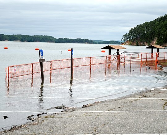
An additional inflow of water has pushed the elevation of Lake Ouachita to 585.1 feet above mean sea level, leading the U.S. Army Corps of Engineers to close more campsites and amenities around the lake.
At 7 a.m. Thursday, the lake elevation was 585.1 feet msl and "still rising, and we have implemented our High Water Action Plan to 586 feet, so we have some additional areas that are being closed down," said Bill Jackson, supervisory park ranger for the Lake Ouachita Field Office.
In comparison, Lake Ouachita's level was 577.46 feet msl on May 20, 2013, and 578.25 feet msl on May 20, 2014. On Memorial Day last year, the lake level was 577.68 feet msl, and 578.14 feet msl on Memorial Day 2013. In 2013, the last high water period on Ouachita, the lake peaked at 586.92 feet msl on June 2, but was down to 577.65 feet on June 2, 2014.
The full pool level on Lake Ouachita is 578 feet msl. Above that level, it is considered to be into the flood pool.
Jackson said the Ouachita River gauge at Mount Ida had dropped to 10 feet by around noon Thursday after reaching 18.6 feet at midnight.
"The Blakely Mountain Dam flood tunnel is not open currently and we're hoping that downstream conditions will allow the tunnel to be opened to release enough water to match the current inflow into the lake to stabilize the lake elevation conditions," he said.
Jackson said Corps of Engineers rangers and maintenance personnel were evaluating all the camping areas around the lake and additional closures could be made if more rainfall is received over the weekend.
The following facilities and areas were closed or being evaluated by noon Thursday:
• Avant Recreation Area -- The boat ramp area was being evaluated to determine how high-water conditions may affect it.
• Big Fir -- The boat ramp was closed, and campsites were being evaluated.
• Brady Mountain -- The day-use swim beach and swimming area, portions of the Corps of Engineers boat ramp parking area, campsites 43-48 and 50-54, the campground beach, and the swimming and parking areas were closed.
• Buckville -- The boat ramp was closed, and campsites were being evaluated.
• Cedar Fourche Recreation Area was closed.
• Crystal Springs -- The day-use area, including both pavilions, swim beach and swimming area, and campsites 23-68 were closed.
• Denby Bay -- The old Highway 270 from Trail's End driveway to LOVIT trailhead, wildlife watchable, ADA elevated trail and the ADA trail were closed.
• Ebon Point -- The boat-in camping area was closed.
• Highway 27 Recreation Area and boat ramp were closed.
• Irons Fork -- The recreation area was being evaluated.
• Joplin -- The campground boat ramp, Corps of Engineers boat ramp adjacent to Mountain Harbor Resort Area, and campsites 15-17, 28-34, 38-40, and 46-63 were closed.
• Lake Ouachita State Park -- Both swimming areas and Three Sisters Springs site were closed.
• Lena Landing -- The entrance road to the boat ramp, campground, and Harbor View Circle Marina area were closed and barricaded.
• Little Fir -- The recreation area and boat ramp were closed.
• Rabbit Tail -- The recreation area were being evaluated.
• Tompkins Bend -- Campsites 17-30, 59, 61-63, 65-66, and 74-77 were closed.
• Twin Creek Recreation Area was closed.
• Washita -- The boat ramp roadway was barricaded.
All areas continue to be evaluated, and closure of additional facilities and areas will be made as conditions warrant. Campsite availability will be updated on the Vicksburg District -- Lake Ouachita Facebook page by 4 p.m. daily through Sunday, Jackson said.
"We are making contact with the National Recreation Reservation Service and updating any new cancellations, and between our office and the NRRS, we're making contact with campers who have reservations. Anyone calling into our office for information on predictions or projections, when they tell us what campsite they are on, we're advising them to really think it through because we don't know what the weather has in store for us," Jackson said.
The National Weather Service forecast predicts chances of rain today through Monday night with the greatest chances on Monday.
Jackson said boaters should wear life jackets at all times, make sure a sober driver is at the controls, and wear the engine's kill switch to prevent accidents from occurring. Swimmers should swim only in designated areas and if swimming from a boat in the open lake, check the area under the surface for underwater hazards.
Jackson also said campers or visitors to the lake should be cautious as the high water will drive animals of all types from their habitat.
"The main thing is reptiles. Animals of all types are being displaced due to the high water, but when walking along the shoreline, people need to be extremely aware of what is on the ground, and be sure to watch where they are stepping," he said.
A Corps of Engineers news release said all recreation areas on DeGray Lake are open, while Lake Greeson has numerous campsite closures, including the following:
• Parker Creek -- The boat ramp and 22 sites are closed; 16 sites are expected to remain closed on Memorial Day.
• Narrows Dam Area -- The beach and day-use expected to be closed through Monday.
• Cowhide Cove -- There are 13 sites closed and limited parking on the boat ramp. Nine sites expected to be closed Monday.
• Kirby Landing -- Seven sites, the boat ramp, and day-use area are closed. Four sites will be closed Monday.
• Self Creek/Jim Wylie -- There are 21 sites closed, but all are expected to be open by Monday.
• Star of the West -- Three sites will be closed through Monday.
• Arrowhead Point -- Eight sites and boat ramp will be closed through Monday.
• Bear Creek -- The boat ramp for small boats only is closed through Monday.
• Laurel Creek -- Six sites and the boat ramp closed; three sites should remain closed Monday.
Local on 05/22/2015