ELEUTHERA, Bahamas -- Hurricane Joaquin unleased heavy flooding as it roared through sparsely populated islands in the eastern Bahamas on Thursday as a Category 4 storm, with forecasters warning it could grow even stronger before carving a path that would take it near the U.S. East Coast.
The storm battered trees and buildings as surging waters reached the windows of some homes on Long Island in the Bahamas and inundated the airport runway at Ragged Island. There were no immediate reports of casualties, according to Capt. Stephen Russell, the director of the Bahamas National Emergency Management Agency.
Prime Minister Perry Christie said he was amending laws to mandate evacuations because some people were refusing to move into shelters.
"We do not know the impact of 130 miles an hour on those areas," he said, referring to the hurricane's winds. "We know it's a horrific kind of experience."
Christie and other top-ranking officials also deflected accusations that the government was not prepared and that residents were not properly advised.
The storm is expected to move near or over portions of the central Bahamas overnight.
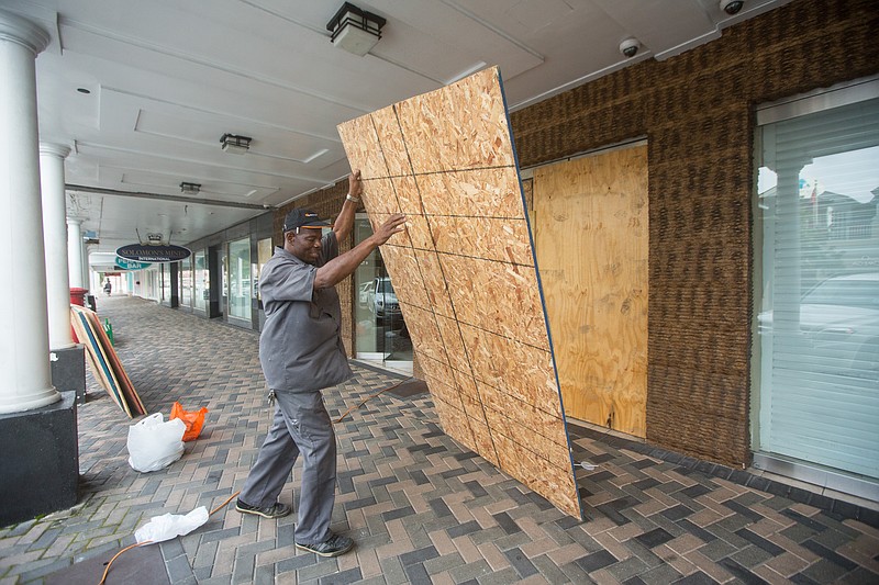
People on the island of Eleuthera braced for the approaching storm late Thursday as they hauled sandbags and boarded up businesses.
"It's going to be a scary storm," said 42-year-old construction worker Jason Petty as he pointed at towering clouds gathering in the distance as the sun went down in Eleuthera. "It looks nice now, but later on it's going to be terrible, just terrible."
Petty was helping friend Demetrius Johnson, owner of Majestic 9 barber shop, prepare for the storm. Johnson had been sharing pictures of the damage in Acklins and other islands through Whatsapp as he waited for the storm.
"People weren't taking this storm seriously until 48 hours ago," he said. "But now it's a Category 4, and we know it's serious."
Christian minister Dawn Taylor said she believed Eleuthera would withstand the hurricane because Bahamians learned how to cope with storms after devastating Hurricane Floyd in 1999, which had winds of 155 mph (249 kph) and generated up to 50-foot (15-meter) waves.
Taylor said people on Eleuthera also are deeply religious and that their faith would carry them through.
"We depend on our God, and as long as he is with us, we will be fine and we will ride out the storm," she said.
The storm approached Eleuthera after it generated severe flooding on Acklins, where power went off overnight and phones were down. Russell said some of the roughly 565 people who live there were trapped in their homes.
Bahamas resident Shandira Forbes said she had spoken to her mother on Acklins by phone Thursday.
"She was calling for help because the sea was coming into her house," Forbes said. "People's roofs were lifting up. No one knew (about the storm), so there was no preparedness, there was no meeting, there was nothing."
Islands such as San Salvador, Cat Island and Rum Cay were expected to be hit hardest before the storm begins an expected shift toward the north, forecasters said.
Joaquin had maximum sustained winds of 130 mph (210 kph) and hurricane strength winds extending 50 miles (80 kilometers) from the eye, the U.S. National Hurricane Center in Miami said. As of 8 p.m. EDT, the storm was located about 25 miles (45 kilometers) east-southeast of Long Island after passing over Samana Cays, Bahamas. It was moving west-southwest at 5 mph (7 kph).
While Samana Cays is usually uninhabited, eight to 10 people were working there, staying in temporary housing, when the storm hit, said Parliament member Alfred Gray.
"If the buildings look like they won't withstand, there are some caves on the side of the rock that they can go into because it's not prone to flooding," he said.
Meanwhile, authorities in the nearby Turks & Caicos Islands closed all airports, schools and government offices.
The storm was predicted to turn to the north and northwest toward the United States on Friday, but forecasters were trying to determine how it might affect the U.S. East Coast, which was already suffering flooding and heavy rains from separate storms.
"There's still a distinct possibility that his could make landfall somewhere in the U.S.," said Dennis Feltgen, a meteorologist and hurricane center spokesman.
The Hurricane Center said parts of the Bahamas could see storm surge raising sea levels 5 to 10 feet (as much as 3 meters) above normal, with 10 to 15 inches (250 to 380 millimeters) of rain falling on the central Bahamas.
The U.S. National Hurricane Center's long-term forecast showed the storm could near the U.S. East Coast along North Carolina and Virginia on Sunday or Monday.
"Residents of the Carolinas north should be paying attention and monitoring the storm. There's no question," said Eric Blake, a hurricane specialist with the center. "If your hurricane plans got a little dusty because of the light hurricane season, now is a good time to update them."
Associated Press writers Ava Turnquest in Nassau and Tony Winton in Miami contributed to this report.
International on 10/02/2015