Some U.S. Army Corps of Engineers campsites on Lake Ouachita have been closed due to high water, and the lake's level was still rising slowly on Monday.
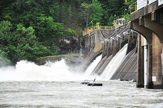
Brian Westfall, a natural resources specialist with the Corps of Engineers, said Monday that the lake's elevation was 581.44 feet above mean sea level as of Monday morning.
The power plant at Blakely Mountain Dam is "generating 24 hours right now to help get the lake level down. The lake is rising slowly. The lake elevation will continue to be evaluated and as conditions change, additional actions will be taken in accordance with the Lake Ouachita High Water Action Plan," Westfall said.
Westfall provided the following summary actions that have been taken as a result of the rising water:
• Crystal Springs Campground -- Campsites 23-37, sites 38-74, and Areas 2 and 3 are closed, and the power has been disconnected. Rocks have been removed from the area adjacent to the Group Camping Area to allow campers to enter and exit through the "High Water Entrance/Exit" location.
• Lena Landing Roadway -- Barricades have been put in place, with the water already across the entrance roadway to the marina area, campground and boat ramp.
• Cedar Fourche -- The lower road leading out to the restroom area is now underwater. The road leading to the rear campground area is also affected, and significant water is standing in the creek area. The Corps does not recommend driving through the creek due to the water's depth.
• Buckville Boat Ramp -- Barricades have been put in place, with the water already up to and covering the boat ramp.
• Little Fir Campground -- Power has been disconnected to campsites 8-13 and 19-24. The elevation of the water has reached the parking lot, and boaters are having difficulty launching and retrieving boats.
• Big Fir Boat Ramp -- Barricades have been put in place, and water has already covered the boat ramp.
• Twin Creek -- Day-use gates have been closed, with water covering a majority of the field and roadway. Water is nearing the edge of the entrance roadway. At the boat ramp, water has covered a large area of the boat ramp parking area and the top of the boat ramp is now underwater.
• Denby Point Boat Ramp -- Jersey barriers at the boat ramp have been marked to alert boaters of underwater hazards once the water covers the barriers.
• Tompkins Bend Campground -- Power has been restored to the area. Campsites 59, 61-63, 65-66, 74-76 are closed and power has been disconnected. Power has been disconnected at the Tompkins Bend marine pump-out area.
• Joplin Boat Ramp -- Barricades have been put in place to warn those attempting to launch of the high-water conditions.
Local on 05/03/2016