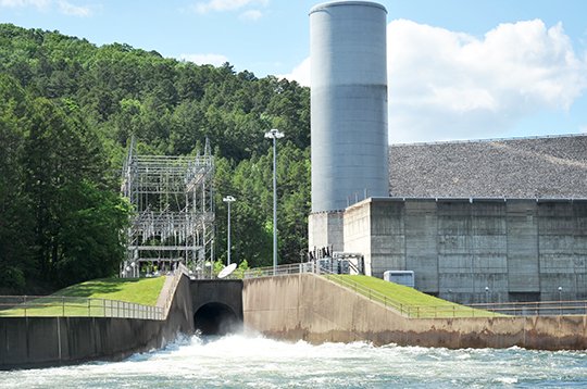
Lake Ouachita began to slowly drop Tuesday as the U.S. Army Corps of Engineers opened the flood tunnel at Blakely Mountain Dam to supplement water being released into Lake Hamilton through hydro generation.
Lake Ouachita had dropped 0.11 foot as of noon Tuesday, said Brian Westfall, a natural resources specialist with the Corps of Engineers. The lake level at that time was 581.36 feet above mean sea level, 3.36 feet into the flood pool, which begins at 578 feet msl.
In contrast, Ouachita's elevation was 581.44 feet above mean sea level as of Monday morning.
The releases were being matched downstream by Carpenter and Remmel dams, which are managed by Entergy Arkansas Inc., and form lakes Hamilton and Catherine, respectively, below Blakely.
While Ouachita was built primarily for flood control, Hamilton and Catherine were built primarily for hydro generation, and have little storage capability compared to Ouachita, so any releases from Blakely Mountain Dam have to be passed downstream for release into the Ouachita River below Remmel Dam.
Westfall noted that all available units were online and generating at all three Ouachita projects -- Ouachita, DeGray Lake and Lake Greeson -- which all fall within the Upper Ouachita Basin.
"This is all based on current river conditions; if river conditions change during this time we will re-evaluate and make corrections accordingly," Westfall said.
Changes in river conditions at any of the three Corps projects "could cause us to re-evaluate the high water plan," Westfall said. "It is dependent on any new rainfall amounts in the watersheds as well as water running off rates downstream. It's all interconnected."
Earlier in the day Tuesday, Entergy sent out an email alert stating that the flow release from Blakely, Carpenter and Remmel dams should be about 9,000 cubic feet of water per second.
By Tuesday afternoon, the release from Carpenter was around 9,925 cfs. The total flow from Remmel was around 10,339 cfs.
According to the National Weather Service's website, 48-hour rainfall through 1 a.m. Sunday was 5.12 inches at Hot Springs. Other amounts included 5.52 inches at Mount Ida in Montgomery County, and 5.40 inches at Little Rock.
"Too much rain" had closed Highway 8 between Norman and Caddo Gap in Montgomery County during that time, the Weather Service said. Water was over Highway 71 at Mena in Polk County, and a landslide had covered part of a road not far from the Albert Pike Recreation Area in Montgomery County.
Minor to moderate flooding was expected or occurring on the Cache, Little Missouri, Ouachita and Petit Jean rivers, it said.
Local on 05/04/2016