Outdoor writer and photographer Corbet Deary is featured regularly in The Sentinel-Record. Today, Deary writes about Sunset Trail from West Mountain to Blacksnake Road.
I recently wrote about the section of Sunset Trail beginning at Cedar Glades Road and ending at Stonebridge. Now, I'm going to address yet another portion of the trail, a 2.9-mile section that begins atop West Mountain and ends at the peak of Blacksnake Road.
With the final weekend of the modern gun deer season still a couple of weeks away, we'll have ample time to discuss the section stretching from Blacksnake to Cedar Glades in the days to come. In turn, those hiking enthusiasts wishing to avoid the deer woods will have plenty of trail awaiting until the 2018 deer season is declared over.
I don't suspect most people even need directions to the trailhead atop West Mountain. However, those not familiar with Hot Springs can simply travel north on Park Avenue and take a left onto Whittington Avenue. Take the first left after entering the loop. The road will run between the medians, cross the opposing traffic on Whittington, and begin a winding ascent.
The road will eventually head back down a slight hill and begin yet another climb. Once reaching the top of the ascent, take a right at the intersection and continue along a steep and winding journey until reaching a loop at the road's end. Simply park at the vista parking area and the beginning of the trail will be just to the right of the barrier.
And how do we get to the takeout point? Well, it's even easier to find. Simply turn left from Park Avenue onto Whittington. Remain on Whittington and turn right and follow the road between the Weyerhaeuser offices and Alligator Farm. Follow the road as it makes a steep ascent up Blacksnake Mountain and turn left into the parking area/Trailhead when the road reaches the mountain's peak.
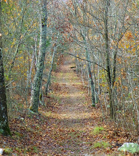
The designated path begins with an easy and level trek along the ridgetop. The designated path meanders within feet of several large boulders and eventually makes its way beneath a power line.
Although the view from the power line is limited, be sure and scan the area for native critters, as I noticed a well-used game trail cutting its way through the heavy understory and through the easement recently.
One might suspect that whitetails are using this path, and rightfully so. But I would suspect several wildlife species might be seen crossing the trail at this point.
The path begins an ascent shortly after crossing the power line easement. Although the climb is obvious, it's not too steep and tops out soon thereafter.
The route then begins a descent, entering an area where towering oaks flourish on the mountainside. This is a beautiful section of the trail as it runs just below and parallels the ridgeline.
This is yet another location where one might see wildlife going about their everyday rituals, as the many oaks provide a preferred food source for an array of critters. However, this year's acorn crop is sparse, which will likely cut down on the number of critters frequenting hardwood stands.
The trail eventually heads back downhill. But as anybody who has experienced very many hikes in the Ouachitas will know, steep climbs often follow descents. Well, this trail is no different, as it begins yet another climb shortly after the trail levels out.
But hang in there, as the climbs can only go as far as the ridgetops. And although one might be forced to slow their pace and occasionally stop for a breather, the views from atop these ridges are often well worth the efforts exerted.
The route does some more up and downing along the way and runs alongside a spur trail leading to the left. Although I failed to hike along this secondary path, I recall trekking along it several years ago. And if memory serves me, the path meanders through the woods for a short distance, prior to ending atop the mountain at a radio tower.
The main trail continues straight ahead while making its way over a few rolling hills. But don't get spoiled to the easy walking, as the route eventually makes several switchbacks while heading steeply up the mountainside.
The designated path eventually tops out again and remains level for a distance, while following the contour of the ridgeline. But I feel compelled to remind you that this trail runs through the heart of the Ouachitas. And seldom does any trail cutting its way through this section of the state remain level for an extended period.
That being said, take a gander at the steep hillside that can occasionally be seen straight ahead. You got it; the route will eventually top out on the mountain. But once reaching this point, one can take a moment to sigh, as the brunt of the climbs will be behind you.
In fact, the trail will meander through several small rolling hills for a short distance prior to making one more slight ascent before veering to the right and beginning an 0.8-mile descent to the spot where this particular section ends.
I am very familiar with the final leg of the walk, as I have trekked this particular section two or three times a week for the past five months. To embark upon the walk from the direction we are traveling in this article is very easy, as you will quickly determine.
Practically the entire walk from the Blacksnake trailhead to this point consists of a steep and relentless climb. Although the hike can prove strenuous, those who are focused on becoming more physically fit certainly might consider this walk. In fact, it was essential to the success of my recent challenge of losing 65 pounds.
The path begins a slight descent from the mountaintop and switches back to the left, heading downhill for a few feet and makes a sharp turn back to the right. Remaining straight for a short jaunt, the path makes yet another switchback before reverting back to a straight run while following the contour of the ridgetop.
The path eventually makes one more switchback, prior to making its way along a fairly level section. But rest assured it won't remain level for long. In fact, the trail eventually begins a steep descent through what I would consider the most rugged stretch of the entire trail.
This is a spot where one must pay close attention to their footing. Erosion has obviously had an adverse effect on this particular section of the trail. Making the steep descent is challenge enough, let alone the large boulders that remained when the soil was washed down the steep hill.
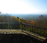
Although one must be mindful of their footing, the hiker might consider occasionally stopping and taking a look at the distant view of the mountainous terrain in front of them and at occasional scenes of Hot Springs nestled in the steep valley to their right.
The descent eventually ends and the trail levels out at the parking area at the Blacksnake Road Trailhead. Although this will prove the end of this section of the walk, I am confident the hiker will have enjoyed their 2.9-mile journey through the woods. And I suspect they'll anticipate the next opportunity to begin at this point and experience a hike along yet another section of the Sunset Trail.
Local on 12/12/2018