Outdoor writer and photographer Corbet Deary is featured regularly in The Sentinel-Record. Today, Deary writes about the final leg of the Sunset Trail from Stonebridge Road to the West Mountain vista.
I have covered a large portion of the Sunset Trail over the past month, as a safe way to enjoy the woods during deer season. Now that modern gun season has ended, I decided to wrap up the series by adding a few other trails into the mix, providing a route back to the original starting point atop West Mountain.
This particular walk begins where the Sunset Trail crosses Stonebridge Road. This access point is easy to find. Simply head north on Park Avenue from Hot Springs and take a left onto Stonebridge Road just before reaching DeSoto Park. Remain on Stonebridge for a short distance and park at the wide spot alongside the pond that is located on the left-hand side of the road.
From the parking area, strike out along the road back in the direction of and cross Park Avenue. Then cross Gulpha Gorge Road and take the trail to the left leading into the woods and along an old roadbed.
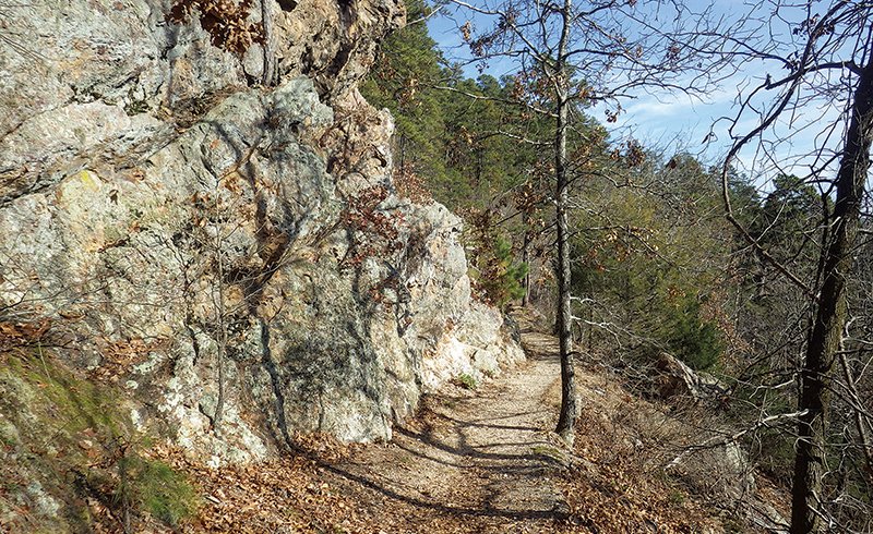
The trail will remain on this old road for a distance while paralleling Gulpha Gorge. In fact, although the designated path will eventually leave the old roadbed, it will continue running within sight of the paved road until eventually reaching Gulpha Gorge Recreation Area.
This section of the route lends to a relatively easy walk. It is fairly level throughout, except for two short flights of stairs constructed of native stones, and one short and steep incline just before reaching the park.
Judging from the map I acquired at the Fordyce Bath House before it was closed due to the partial government shutdown, Sunset Trail actually ends at this point, where it ties in with the trail system that traverses Hot Springs Mountain, lending to an opportunity to continue in the direction of downtown Hot Springs.
There are several interconnecting loops one can choose from, all of which will eventually lead over the mountain to the Bathhouse Row area. However, by remaining right throughout practically the entire walk, the hiker will experience what I consider as some of the most scenic sections of the designated paths.
The trail makes its way up a flight of natural stairs and makes a quick switchback and heads up the hill at a pretty good pace to an intersection. One could remain straight on and follow the Dead Chief Trail back to the Promenade. However, we will take a right at this point and follow the path as it makes a couple of switchbacks and continues an ascent. The designated path makes its way to yet another trail intersection just past the switchbacks. One could take a left at this point and follow the path to atop the mountain. But we'll remain straight on Gorge Trail.
The path runs fairly level for a distance, providing a great opportunity to catch one's breath following the ascent to this point. The beaten path will run alongside a huge boulder, referred to as Goat Rock, shortly thereafter and to yet another trail intersection on the left.
One might consider making a short detour along the spur trail as is leads to and ends atop the boulder. For some reason, the main trail's name also changes at this point. So we will be hiking along the Goat Rock Trail for a short distance, until the path reaches and continues along the ridgeline.

The route remains level for a while, cutting its way through an abundance of novaculite. But it eventually begins yet another ascent to the mountaintop. Although the elevation gain is substantial, the climb seems fairly mild, as a result of three switchbacks.
The designated path then makes a hard turn to the left and follows the contour of the ridgeline. This is a section of path that I return to several times annually, during the spring and early summer, as a diversity of interesting plants thrive within feet of the trail.
The route follows the ridgeline for a short distance before ending at the North Mountain Loop Vista. This is another spot that is well worth taking in, as the view is incredible. But the intersection of the route we will continue along is on the right just before reaching the lookout.
So we'll take a right onto the Dogwood Trail (upper loop), and remain on this path through a section of incredibly beautiful woods. Hardwoods tower into the sky along this section of the route, with little understory obstructing one's vision of the hillsides. This is another one of those locations where one who walks softly is apt to see distant whitetails and other native critters going about their everyday rituals. This section of the path also lends to a very easy walk.
The trail eventually makes its way to yet another intersection, where we'll veer right onto the Dogwood Trail (lower loop). This too, is a great section of the designated path, which we'll remain on until reaching and turning right onto Floral Trail. Floral Trail slightly traverses down the hill for a short distance and crosses the Hot Springs Mountain Drive.
We'll actually take a right and follow the road for a short ways and cross Park Avenue at the Arlington Resort Hotel & Spa. Once crossing Park Avenue, turn right and follow the sidewalk to Whittington Avenue. Take a left and continue alongside Whittington.
Continue alongside the road for about a half mile, cross the road leading atop West Mountain, travel a few hundred feet and take a left onto the trail leading into the woods.
You got it. This section of trail makes an ascent to atop the mountain. So be ready to do a little climbing. But don't get too worried, as several switchbacks make the climb far less difficult than one might expect.
From Whittington Avenue, the designated path makes a short journey along level ground before making a short ascent to an intersection atop a knoll. I have actually chosen to take a left at this point, and still made it to the same destination in the past. But by this point in the hike, I would suspect some are ready for the journey to be over, That in mind, we'll remain right and follow the path as it winds up the steep mountain via the aforementioned switchbacks.
The trail eventually reaches the ridgeline, at the final intersection of the hike. This spot might look familiar to those who have already hiked from West Mountain to Blacksnake Road, as we have just reached an intersection of the Sunset Trail.
Simply take a left at this point and walk a short distance to the parking area atop West Mountain. From this point, those who have tackled the entire journey I have covered during the past month can enjoy the wonderful view of the city while savoring the experience of their completed trek along the Sunset Trail. And I suspect there will be those who share my appreciation for such an impressive trail that is easily accessible from Hot Springs.
Local on 01/08/2019