Outdoor writer and photographer Corbet Deary is featured regularly in The Sentinel-Record. Today, Deary writes about Sunset Trail from Blacksnake to Cedar Glades roads.
Having recently written about the sections of Sunset Trail stretching from Cedar Glades to Stonebridge roads and from the West Mountain summit to Blacksnake Road, it's due time to focus on the section of trail resting between these two destinations.
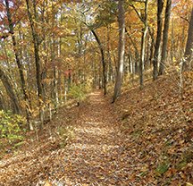
This particular section of designated path begins atop Sugarloaf Mountain, where the trail crosses Blacksnake Road and meanders northeast for approximately 2.8 miles through typical Ouachita Mountain terrain prior to ending where the trail crosses Cedar Glades Road.
Those who have already hiked the most recently covered route beginning at West Mountain will have likely already figured out that there is no shortage of climbs and descents along the beaten path.
Well, this section is not much different, as the walk begins by heading steeply down a hill, and begins its first climb shortly thereafter. It seems to me, however, that the climbs awaiting those embarking upon this trek are not quite as steep as were the aforementioned section.
I also found it intriguing that some interesting history lurks along the section of path between Blacksnake and Cedar Glades. According to information posted by the National Park Service, portions of this trail pass through property that was once owned by Henry Massie Rector. Rector was the first Confederate governor of Arkansas during the Civil War.
After heading steeply down the hill, the trail runs fairly level along the remnants of an old roadbed that has been cut into the hillside and parallels the distant ridgeline to the right. The path also leaves the pine forest behind and continues under the canopy of towering oaks.
The path doesn't run level for very long, though, as it heads steeply up a hill and eventually veers to the right as the ascent continues. I'll be the first to agree that this is a fairly long and steady climb. But hang in there, as the designated path eventually reaches and turns left along the top of the ridgeline. It will continue following the contour of the ridgecap for a distance, lending to an opportunity for one to catch their breath and enjoy the scenery.
Speaking of scenery, the environment makes a noticeable change after reaching the top of the mountain. Large outcrops of novaculite boulders are abundant alongside the trail. And the towering oaks and large pines no longer thrive in this type of terrain. Although huge trees are sparse, there is no shortage of short and scrubby trees that evidently thrive in low soil content and can withstand the winds that notoriously blow atop mountains.
I suppose one could say that this section of the trail is not as scenic as are the spots shaded by a bountiful canopy. But I personally enjoy walking through such areas, especially during the late spring, summer and early fall seasons, when lizards and other sun-loving critters can be seen going about their everyday rituals; let alone wildflower species that also thrive in this particular environment.
The trail eventually veers to the left and leaves the ridgeline behind, just before crossing a power line twice and heading up a hill. Entering a wooded area, the path wastes little time prior to making a steep descent along what likely proves the most rugged terrain along this particular trek.
The path eventually levels however, and makes its way to the intersection of a spur trail leading to Balanced Rock 1.6 miles into the journey. Although there was once a sign at this point, only a 4-by-4 post is left standing. Just bear in mind that the trail is to the left, just beyond where three rocks are stacked atop a post.
The trek along the Balanced Rock Trail only consists of two-tenths of a mile. But don't let the short distance fool you, as it is well worth the effort. The walk is actually fairly easy and leads to a huge boulder formation at the path's end. One must watch their footing near this structure. However, the view of distant valleys and mountainsides is impressive. In fact, this would prove a great location where one could carry along and enjoy a picnic. Carry along a snack bar, stop and enjoy the surroundings at this location, at the least.
The walk back to the main trail is also pleasant and scenic, as well. In fact, I noticed one spot in particular where one can see another large boulder lurking just off the beaten path. And I suppose the view of this natural structure will become even more clear as the leaves continue to fall from the trees.
From the intersection, the main trail continues through a bountiful forest. It continues a few small climbs and descents that are typical to our section of the state. And it eventually enters one of my most favorite sections of the entire trail system. In fact, it enters an environment which I consider as one of the most beautiful sections of woods throughout the entire Ouachita Mountains.
It one of those super-special spots, where I could return time and time again, and never grow bored. Huge oaks tower on the hillside to the right and the slope to the left. There is no understory whatsoever, lending to an opportunity to see forever through the woods. This is one of the spots where one's imagination can soar. I always picture a trophy buck browsing the forest floor for their favorite morsels when the acorns plummet from the beautiful white oaks that are so abundant in this area.
And then there's that magical time of the year when the gobblers beckon their harem of hens. I can imagine these pristine and wary toms working this area, as although sheltered deep in the forest, they can easily be seen strutting by any potential mates.
I can even imagine the lonesome sound of owls bellowing under the cover of darkness and them silently gliding from limb to limb in search of their next meal. Yep, this is a spot where any and all critters native to the state might be seen going about their everyday rituals.
The trail eventually begins its final descent prior to reaching the takeout point. Although the downhill slope is steep and must be traversed at a slower pace, those who choose to travel the route in the opposing direction will begin their journey with a tough climb.
The trail makes its way to the access point shortly after making the descent, and crossing the road to the parking area. Upon finishing my recent trek along this particular section of the Sunset Trail, I looked back with a smile. This was a walk that I would return to enjoy again in the near future. And the fact that it is located just a few minutes from downtown Hot Springs was just "icing on the cake."
Local on 12/18/2018