EDITOR'S NOTE: Outdoor writer Corbet Deary, a regular contributor to The Sentinel-Record, writes about his experiences biking a portion of the newly opened Northwoods Trails system.
Last month, I covered the green section of the Northwoods Trail System. And although there was plenty on this short section of designated path to beckon me back time and time again, I decided to stray a little farther and check out the blue trail, which is designed with the intermediate mountain bike rider in mind.
This particular section of trail is in the neighborhood of 4 miles in length -- other sections of trail were opened in late December -- but as of right now, I will focus on the initial section of the intermediate trail that has been welcoming riders since mid-November.
One can actually reach this path from Cedar Glades Trail. However, I will begin the description from the city waterworks trailhead, which is the same location from where we began our recent journey along the green route.

I failed to mention one of the perks of beginning at this point during my previous article. I was impressed upon noticing a bike maintenance station at the beginning of the ride. This is a perfect spot to check the air in one's tires and make any small adjustments either prior to or at the excursion's end.
Those beginning at this point will start their ride along the green trail. But a short section of the blue trail will veer to the right shortly thereafter. And although this section makes a short jaunt before tying back into the green trail, it is certainly worthy of mention. The path heads slightly up a hill and runs along a mountain while paralleling one of the city's reservoirs.
The path makes its way over a few boulders along the way and makes one sharp turn prior to tying back into the original trail.
Following the green trail to the intersection, take the trail to the right and continue along the easy trail as it makes a hairpin turn, heads downhill and crosses a small branch. The path will lead to yet another intersection shortly thereafter. The blue trail veers to the right at this point, making its way over a rock structure and heading down the hill into a drainage area.
The next few miles of designated path will be designed with intermediate riders in mind. However, one can tie into the black trail at a couple of spots throughout the ride, as well.
But be aware that the black trail is not for the faint of heart. In fact, I would strongly suggest that one walk this most difficult trail prior to ever attempting to ride it. There are a couple of obstacles, including jumps, that should only be tested by the experienced riders.
After crossing a branch, the blue trail leaves the low-lying area behind and begins a long ascent. And when I say long, I mean long. In fact, I have intentions of utilizing this winding section of the route to improve my cardio fitness.
I have previously been riding to atop Hot Springs and West mountains, back to back, as a means of remaining fit during the months when it is too cold to embark upon long rides on my road bike. But I suspect this section of mountain bike trail will prove even more of a strain than what I have grown accustomed to riding.
The route actually runs practically within a stone's throw and within sight of a couple of the aforementioned jumps while making its way up the hill. That being said, one might stop their ride and catch their breath while walking over to and checking out these sections of the black trail.
The blue trails continues a winding ascent, occasionally making its way over and around boulders before finally topping out on the ridgeline at an intersection. The section of black trail leading to the most difficult segment of the trail system is on the right.
The trail to the left is the section leading to the Cedar Glades trail intersection. And although this is also a portion of the black trail, it is not as unforgiving as the jumps. However, the intermediate rider might find it necessary to occasionally dismount and push their bikes along this section of trail, if they choose to ride this particular route.
Now for the blue section, which remains straight at the intersection. This particular stretch is likely the most exciting stretch of the blue trail that was originally opened to the public.
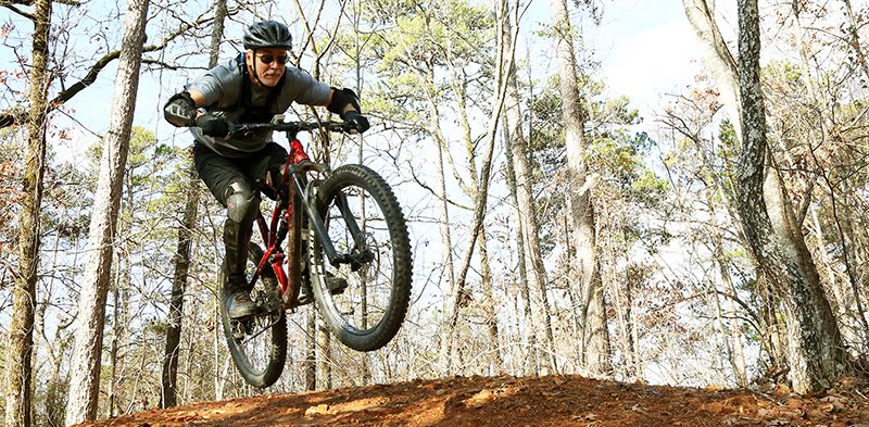
In fact, the first part of this section heads downhill and over several berms. Although the descent is fairly mild, one can easily gain enough speed to get a little air between the humps. In fact, some riders actually dedicate extra time to riding this section several times before continuing along the remainder of the blue path.
The trail winds through the woods after making its way over the berms and eventually shares a section of designated path with the black trail. But fear not, as this stretch of trail is designed with the intermediate rider in mind. However, the first descent is steep and fast. But it will be the most trying section for the remainder of the ride.
The route meanders down the hill and eventually ties back in with a section of the green trail that we originally traveled while en route to the blue trail. The path cuts its way through a low-lying area for a short distance, crosses a branch and makes a slight ascent up the hill, around a hairpin turn and reaches an intersection atop a knoll.
I suppose one could continue to backtrack at this point. But I would suggest taking one of the two paths straight ahead and take in a section of the green trail while heading back to the trailhead. Either of the two green trails lends to an enjoyable ride and will lead back to the starting point shortly thereafter.
Within the neighborhood of 35 more miles of trail to be at riders' disposal in the future, I am very excited about the Northwoods Trail System. In fact, it promises to beckon mountain biking enthusiasts from abroad.
And although there are a few particular sections that are far beyond my skill level, I will experience a bulk of the trail system first hand. In fact, I'll step out on a limb and suggest that I'll return back to ride the blue section of the Northwoods trail time and time again.
To reach the waterworks access point from Park Avenue, turn onto Whittington Avenue and immediately take a right onto Cedar Street. Follow Cedar Street for a short distance and turn right onto Cedar Glades Road. Follow Cedar Glades over the mountain and turn right at the gate while heading down the hill where the main road makes a hard turn to the left. After turning to the right, follow the road to its end and park at the city waterworks facility.
Local on 01/18/2019