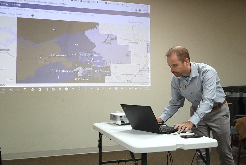
The 2020 redistricting draft map presented to the Garland County Election Commission Thursday adjusted justice of the peace boundaries to account for the urban to rural shift in the county's population since the 2010 census.
JPs represent their constituents on the Garland County Quorum Court, the county's budgeting and appropriating authority. They set county employee salaries and policies and adopt ordinances affecting the health, welfare and safety of county residents.
The part-time legislators serve two-year terms, meaning all 13 seats will be up for election next year. The filing period begins Feb. 22, according to the state's election calendar.
District 8 had the biggest population growth, with 8,587 people living in the area along the Highway 70 west corridor in southwest Garland County on April 1 of last year. That's the date the U.S. Census Bureau uses to determine where people are living when they are counted for the decennial census.
The map DataScout LLC presented to the county election board moved 688 people out of District 8, putting it 2.56% over the 7,702 target population for each of the 13 JP districts. The target is the quotient from dividing by 13 the more than 100,000 people the 2020 census recorded in the county.
District 8 had the largest variance from the target population on the map presented Thursday. District 13 in east Garland County had the smallest. Its 7,710 population is within 0.10% of the target.
The map added more than 1,700 people to Districts 1, 2 and 3 in north, west and central Hot Springs to move them within 3% of the target. More than 1,600 people were shifted from the more rural districts 6, 7, 8, 9, 10, 12 and 13 to put them within 3% of the target.
Video not playing? Click here https://www.youtube.com/embed/cNLWIp6VVj4
"Almost every county we've worked with, the city has grown and the rural areas have shrunk," Matthew Charton, DataScout's director of geospatial services, told the election commission.
"You guys were the opposite. Your city has actually shrank in relation to your more rural districts. Other counties, the rural districts grew into their cities. Your city ended up growing outward into your rural areas," he said.
District 9 in southwest Garland County ceded the area west of the Highway 70 west bridge to District 4, putting District 9 entirely within the unincorporated area of the county. Moving the northeast part of District 8 into District 9 offset the loss, expanding the southeast piece of District 9 south to Highway 70 west. Charton said the shift moved more than 600 District 8 constituents into District 9.
District 9 also ceded the area west of Daisy Hill Circle and south of Highway 270 west to District 10.
District 2, which the election commission said is the only district the draft map placed entirely within the city of Hot Springs, retained its majority-minority status. It lost part of its northeast section, an area Charton said has a white majority, to District 1 and gained a piece of District 3 south of Hobson Avenue and part of the Ridgeway Street corridor currently in District 1.
The election commission will meet Dec. 1 to consider publishing the draft JP map for a 30-day public comment period. Charton said the commission has a Jan. 3 deadline to adopt the map.
The boundaries were drawn to minimize the creation of new precinct parts. The county has 56 reporting precincts. Within those are precinct parts, many of which have unique ballot styles.
"Depending what's on the ballot, there could be as many as nine ballot styles in some of them," Election Commission Chairman/County Election Coordinator Gene Haley said, referring to the 56 reporting precincts.
He said the county had 58 ballot styles during last November's general election and more than 120 during the March 2020 preferential primaries, annual school elections and nonpartisan general election.
"Which is why you can't do paper ballots at the polls anymore," Haley said. "The chance of somebody getting the wrong ballot is huge."
