Outdoor writer and photographer Corbet Deary is featured regularly in The Sentinel-Record. Today, Deary takes readers on a journey to Kenny Vernon Nature Trail.
I happened upon the Kenny Vernon Nature Trail a number of years ago, and I have returned to this particular destination on several occasions, for good reason.
Situated in the Bell Slough Wildlife Management Area, the beaten path meanders through a relatively level terrain, lending to an easy and pleasant jaunt.
One has a choice of distances as the route consists of two interconnecting loops. Those taking in the entire trail can expect a 2.25-mile walk. Those choosing to walk the outer perimeter will travel 1.75 miles prior to the walk's end. And those embarking upon a hike along the south loop will have 1.3 miles of dedicated trail in front of them.
I have taken in the entire route on occasion. However, I most enjoy the 1.75-mile walk along the outer perimeters of the trail system. In fact, that's the exact route I took during our most recent visit to the management area. And in turn, that's the section of trail that we will cover today.
However, before focusing on the walk, let's begin with directions to the destination. From Hot Springs, take Highway 70 east for about 17 miles and merge onto Interstate 30 east.
Be aware that you will enter a construction zone immediately after entering I-30. This particular section of the drive might prove slow and somewhat nerve-wracking. But continue on, as you will leave the barriers behind and the interstate will open up a few miles down the road.
Remain on I-30 for 13 miles and take Exit 129, onto Interstate 430 north. Remain on 430 for 13 miles and take Exit 13B, onto Interstate 40 west, toward Fort Smith.
Remain on I-40 for 12 miles and take Exit 135 at Mayflower and take a left onto Interstate Drive. Continue on Interstate Drive past Gibson Bridge Road and turn left into the parking area immediately after crossing Palarm Creek.
Video not playing? Click here https://www.youtube.com/embed/Q-Q2XOd0dhE
OK, looks like we made it. Now let's begin our jaunt through Bell Slough via the Kenny Vernon Nature Trail.
From the trailhead, the designated route makes its way to a well-designed boardwalk winding through a low-lying area. There are times when the substrate beneath the structure is dry. However, it doesn't take much precipitation for water to back up. In fact, I have seen the boardwalk underwater on more than one occasion, deeming the trail impassible.
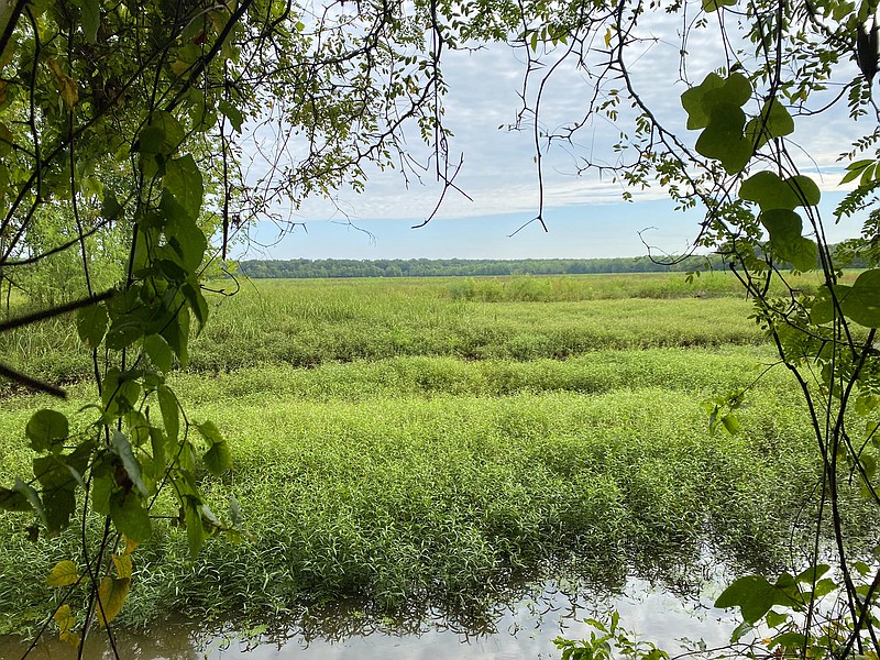
The path meanders over the slough for a short distance prior to tying back in with the natural substrate and easing to a viewing area, overlooking a large field.
Although it appears as hardly anything more than a field, during the summer months, one is apt to see various songbird species frequenting the area. And the wildlife viewing opportunities will increase as the winter season nears, as migratory waterfowl sometimes utilize the area as a resting spot.
Although one can hardly see through the thick windrow of vines and saplings, the trail runs alongside the waterfowl rest area for a distance and eventually makes its way to yet another opening at the back corner of the field.
This is also a great location from where one might get a view of native wildlife going about its everyday rituals. In fact, I can recall stopping at this exact spot on a sultry summer day and watching a Mississippi kite feeding on dragonflies.
From the field's corner, the trail heads back into the woods, makes an abrupt left-hand turn and traverses a slight incline via a set of stairs. The designated path then enters a wooded area, consisting predominantly of hardwoods.
Although I have never seen a deer at this spot, it certainly looks like a location where one might see a white flag suddenly bound into the distance and out of sight.
The path continues through the wooded area, eventually making its way to a spur trail on the left. This route makes a short jaunt to an impressive photo blind. Again, I have not seen a lot of wildlife in this area. But that's no indication that critters avoid this section of woods. In fact, I would believe just the opposite, especially during years when the acorn mass is plentiful.
OK, I have failed to see any animals along this stretch of the trail. However, I do recall happening upon a very interesting plant a few years back. The fringed orchid had taken root within inches of the trail and was in full bloom during the discovery.
The trail eventually veers to the right and meanders through a section of woods that appears to have recently been thinned. Again, I would not have been the least bit surprised to see a whitetail, suddenly bounding through the understory.
The beaten path continues to veer right and makes the most significant ascent of the entire route. And this climb is hardly anything to be dreaded. In fact, it's rather mild and short.
Making its way alongside several trees that have recently been planted the trail veers farther to the left at the hilltop and enters an environment that is far different from the low-lying area that it has used during the previous portion of the hike.
The route continues atop the knoll for a distance, making its way alongside a wooden structure overlooking tall grass. This, too, appears to be a location where native wildlife might frequent. In fact, an interpretive sign atop the hill shares photos of several different native animal species that might be seen in this particular environment.
The path then makes its way back into the woods and begins a slight descent into more of a low-lying area. However, it provides a totally different environment from what we walked through at the beginning of the hike, as the substrate is obviously drier.
In turn, totally different tree and plant species thrive. Pine trees can be seen growing in the midst of various hardwoods, and muscadine vines appear to prefer this particular habitat, as well.
The trail remains relatively level for a ways and eventually makes its way back to the spot where the path makes a slight ascent via stairs. We will simply backtrack to the trailhead from this point. However, that's no indication that the remainder of the walk will prove uneventful or boring.
It is not uncommon to happen upon views that went totally unnoticed while hiking the opposing direction along a trail. And this route is no different, especially in light of the fact that one will have yet one more opportunity to stop for another glance into the field from the dedicated wildlife viewing area.
In fact, knowing that the vehicle is only a few minutes away, this might prove an opportunity to dedicate some extra time to this particular spot.
Who knows? Those who are most patient might have the opportunity to see some of Arkansas' native wildlife unsuspectingly going about their everyday rituals. But at the worst, one will get just a little better acquainted with a small section of land situated in the midst of the wonderful outdoors.
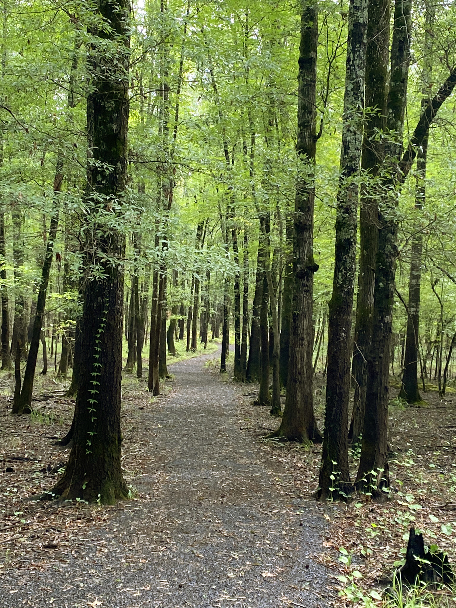 The Kenny Vernon Nature Trail makes its way along predominantly level ground, lending to a pleasant and easy trek through the forest. - Photo by Corbet Deary of The Sentinel-Record