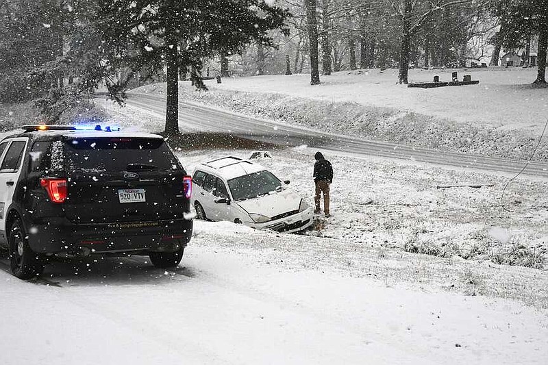
Emergency personnel spent much of Friday morning working mostly noninjury wrecks as 2024's first round of winter weather hit the area.
According to the National Weather Service in North Little Rock, Garland County received between one-tenth to an inch of snow and sleet early Friday morning, which is more than what was originally expected.
"Just going into this event, we knew we were going to get some early morning precipitation with the temperatures hovering right around freezing," Dennis Cavanaugh, warning coordination meteorologist with the state's NWS office, said.
"The forecast certainly had already called for some snow transitioning over to rain. The snow as it fell though -- the ground temperatures are sitting just above freezing. The snow fell so hard that even though the ground temperatures are above freezing, the snow was able to stick, even on roads in many cases. While the snow was piling up, it was still melting, but it was piling up faster than it was melting."
Video not playing? Click here https://www.youtube.com/embed/hWMt8aFPjpE
Cavanaugh said temperatures were expected to remain above freezing throughout the night Friday.
"The winds are actually shifting around to the south," he said Friday afternoon. "Even though the roads are very wet -- and if the temperatures were to plummet after this, we would have some pretty serious icing problems -- the temperatures are going to hold pretty steady over the next 12 to 18 hours here. The winds are shifting around from the north to the south. While that's not going to warm us up necessarily, but it will prevent the temperatures from falling."
Garland County was fairly representative of central Arkansas as far as snow accumulation, Cavanaugh said.
"Pulaski County, Saline County, Faulkner County, Lonoke County -- all of those areas pretty much saw snowfall totals up to an inch," he said. "There were some isolated instances where, I think maybe in West Little Rock, somebody measured an inch and a half, but by and large snowfall up to about an inch before changing over to rain and melting off is pretty much what happened across most of central Arkansas. In the higher terrain, in the Ozarks and Ouachitas further to the north and west, there were some higher snowfall totals, but it's pretty far north and west of Garland County."
Sgt. John Schroeder said the Garland County Sheriff's Office worked seven weather-related wrecks Friday morning, the first around 8:55 a.m. The Hot Springs Police Department worked five wrecks that were weather-related, starting at 9:30 a.m.
"It was pretty evenly distributed around the county," Bo Robertson, Garland County Emergency Management Director, said. "I mean, we all got snow, but it seemed like most of the accidents were Highway 70 east, East Grand over that way. We had an eighteen-wheeler jackknife. We had a couple of -- I think it was a head-on accident over there as well, and several vehicles that just slid off into the ditch."
Robertson said Highway 290 and Park Avenue both were "pretty rough," but there were incidents all over the county.
"It was really pretty evenly distributed," he said. "There were a few vehicles that slid off Albert Pike, Amity Road. There was one that slid off of Bull Bayou and Blacksnake there, so it was pretty hectic for a little bit. Highway 7 south got it pretty good."
While there were no reports of downed trees or power lines from this system, Robertson expects some from the storm system moving into the area early next week.
"We're supposed to get really, really high winds Monday into Tuesday of next week -- 30, 40 mile-an-hour winds," he said. "That's probably when we're going to start seeing some of the trees come down and power lines come down with them."
Cavanaugh said temperatures are expected to climb throughout the weekend, peaking around 50 degrees Saturday with lows hovering near freezing.
"That'll hold for Saturday and Sunday," he said. "Then our next big weather system comes in on Monday. It looks like during the day on Monday though, it's going to be mainly in the form of persistent light rain or some heavier to moderate rain at times. The weather system on Monday into Monday night and Tuesday, that's more traditional of what we expect.
"We don't usually have snow beginning transitioning over to rain. We usually end up with liquid precip that transitions to frozen precip, and that's more common and what we expect to happen Monday night into Tuesday," he said.
While there is a possibility of "light wintry precip" Monday night, Cavanaugh said it will mostly be further north.
"It does look like Kansas, Missouri are going to get quite a bit of snow from that system," he said. "So the snow impacts won't be far from us, but they should be north of Arkansas, and then really just kind of seasonal temperatures.
"So it's definitely going to get colder Monday night into Tuesday, but we're not talking like an Arctic plunge here. Temperatures will get well below freezing Tuesday night and will stay cooler in the day on Tuesday just due to cloud cover, but they're going to rebound back into the 50s as we get into midweek."