Outdoor writer and photographer Corbet Deary is featured regularly in The Sentinel-Record. Today, Deary writes about Hawksbill Crag.
Odds suggest most of us have seen photos of Hawksbill Crag in various publications throughout the years. This destination is probably one of the most-photographed locations throughout the entire Ozark National Forest, and rightfully so. From atop the rock formation, the view is incredible, lending to a beautiful perspective of the jagged and steep mountains the northern section of our state is noted for.
Although many shots of it are admirable, there's nothing like seeing the view firsthand. Fortunately, the trailhead is not hard to find, nor is the trail leading to the destination overly strenuous. I would not personally suggest this as a destination for pets or small children, as one misguided step would lead to a terrible fall.
I would, however, recommend this trek to all others who are in reasonable physical condition and long to experience the wonders of the outdoors. Those embarking upon the walk will have the opportunity to see a very special place, indeed.
Located in the same proximity as the destinations I covered last week, the directions from Hot Springs are practically the same. Take Highway 7 north to Russellville and turn left (west) on Interstate 40. Travel 17 miles and turn right onto Exit 64. Take a right onto Highway 64, go 5.5 miles and turn right onto Highway 21.
Travel 28.1 miles and turn right where highways 21 and 16 merge. Go just over 18 miles and turn left onto a dirt road immediately after crossing the Buffalo River.
This road can be traversed by just about any vehicle, but one should bear in mind that it is a dirt road. So those who do not like navigating their vehicle through occasional chuckholes and muddy conditions might consider another destination.
And did I mention this road was also steep? The first mile heads straight up the mountain before finally leveling out and pretty well running along the top of the ridgeline.
Anyway, those embarking upon a journey along the road will be privy to some interesting scenery before reaching the trailhead. While making the ascent, one will see a couple of sheer rock formations on their right, that during the winter months will sport some pretty impressive ice formations.
Once reaching the ridgeline, the road will make its way alongside a couple of farms and at 5.4 miles will run alongside Cave Mountain church and cemetery on the right-hand side of the road. Continue about a half-mile past the church to the trailhead parking area, located on the right. The trailhead is actually located on the opposing side of the road from the parking area.
With the drive behind you, it's time to embark upon a trek into the forest. Judging from the terrain, one might suspect they are in for brutal hiking. But looks can prove deceiving, and the walk will not be as remotely as tough as one might think. Granted, there will be one long ascent back to the vehicle, and a few ups and downs along the way, but generally speaking the walk is fairly level.
The path begins by making its way through a wooded area, but eventually beginning its only lengthy descent throughout the entire hike. The hill was rather steep, but the trail made two switchbacks during the process, deeming the walk fairly mild.
I will say that this hill was much more noticeable while en route back to the vehicle, as making ascents are naturally tougher. It wasn't, however, a climb to be dreaded, especially if the hiker will simply take their time and enjoy the surrounding beauty.
Once reaching the bottom of the hill, the trail made its way through another level area. During the summer months, the section of the route would likely prove dry, but during the winter months be prepared for a little standing water.
A cold overnight low had frozen the water during our most recent visit, but the trek wasn't treacherous, as we simply walked in the woods on the high side of the trail. This portion of the walk made its way through a typical forest environment, but it wouldn't be long before the scenery made a drastic change.
Reaching a steep draw, the path made a hard left-hand turn, running alongside the steep hillside for a short distance before making an abrupt right and crossing the creek. Upon stepping across the creek, it quickly grew evident the scenery was on the verge of change, as we could hear the roar of a small waterfall in the distance.
Within no time, the trail made its way to the edge of a bluff line and within sight of water pouring over a sheer formation to our right. Although active at the time of our excursion, I would suspect this water spectacle only makes a scene during the wetter times of the year, hence the reason the trail does not head in that direction.
Instead, it made a sharp turn to the left, paralleling the bluff line. To this point, we had seen very few rock formations alongside the trail, but things had changed drastically. In fact, the farther we walked, the more prominent they became.
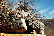
Although intrigued with all rock formations, I found some of the ones within sight of the route most interesting. It literally looked as some of them had been meticulously stacked. Some of the huge boulders appeared as if they balanced on the structures below them, while others appeared as several pieces of puzzles lying in a pile. It was a sight to see.
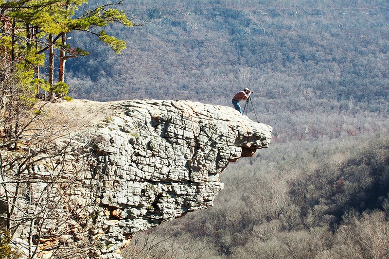
But that was nothing compared to what waited at the trail's end. No matter how many times I visit this particular spot, I am always awe-inspired upon seeing the huge rock formation protruding from the mountainside. Bolting out what appears several hundred feet above a rugged and steep valley below, the rock formation lends to a view unsurpassed. Upon nearing the ledge, we noticed two red-tailed haws soaring below. That's right -- I said below.
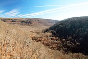
Looking to the left from atop the crag, one can see a distant ridgeline running left to right. Another jagged ridge, running perpendicular to the one on the left, lurks straight ahead.
Peering to the right, one can see the sheer bluff that paralleled the trail through the final leg of the journey, and the winding valleys below are a reminder of the altitude of the crag on which we were standing.
Walking near the edge, it is somewhat overwhelming to peer down, as the realization that one false move could lead to disaster. Although not likely the case, I got a feeling that a stiff wind could force me over the side.
But one does not have to push their luck to enjoy the view. In fact, I discourage nearing the edge. Even those who do not favor heights can take in the beauty around them from a comfortable perspective.
After taking in the scenery and lying on the crag and basking in the sun, we eventually opted to bid farewell to one of the most beautiful locations throughout Arkansas' forests. While trekking back to the vehicle, I imagined watching a lightning storm brew in the west on a sultry summer night. And even though I would likely never experience the picture my mind painted, I would certainly embark upon this 3-mile round trip again in the future to get even better acquainted with Hawksbill Crag.
Local on 01/22/2015