Outdoor writer and photographer Corbet Deary is featured regularly in The Sentinel-Record. Today, Deary writes about the Cedar Glades Park trail system.
Those of us living in the general vicinity of Hot Springs are fortunate in the sense that we have several miles of pristine trails, right here in our backyards.
Of course, some of these designated paths wind through the national park. However, there is yet another park and trail system within minutes of town that is certainly worthy of mention.
Cedar Glades Park has something to offer to folks with a wide array of interests. The RC flying field is a great location where folks can enjoy maneuvering remote-controlled airplanes through an open sky. Those with a passion for disc golf often gather at the park and embark upon a little friendly competition at a world-class course. And let's not forget those who savor the opportunity to simply get out and enjoy the sheer beauty of the wonderful outdoors.
The park also sports an impressive trail system, consisting of in the neighborhood of 15 miles of paths winding through the 432-acre facility. Of course, the trail is opened to hiking. It is most utilized, however, by mountain biking enthusiasts. In fact, the succession of interconnecting loops was previously voted as the "Best Trails in The State" by the Arkansas Mountain Bike Racing Series.
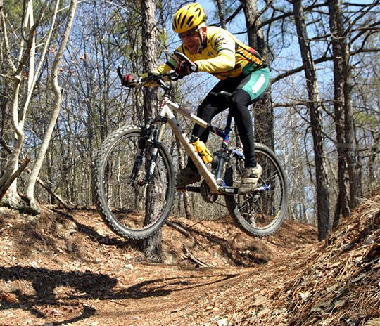
One would only suspect that any trail earning such a title is capable of testing the most avid of riders. Well, the Cedar Glades trail system does provide the experienced with ample hairpin turns, steep hills and obstacles to earn their respect.
Fortunately, there are also sections of the trail system that can be ridden by those of us who are not as adept at riding. I'll be the first to admit that even these sections pose obstacles that are far beyond my riding capabilities.
Yeah, I might occasionally have to unseat and push my bike. But shortly thereafter, I'm back in the saddle and enjoying a winding and exciting ride along the remainder of the trail.
The trail system consists of three major loops -- the Black section, the Blue section and the Green section. The Black section is classified as "most difficult." I suspect most of the avid riders who might read this article are already aware of this 4.6-mile stretch of trail. That in mind, I will focus on yet another section of designated route that might prove more suited for those who are not quite as skilled as those who ride on a regular basis.
The section I plan to cover consists of the remaining two interconnecting sections. I originally considered covering them separately. However, upon riding the two loops, it quickly grew evident that the map that can be picked up at a kiosk near the trailhead is somewhat misleading.
First and foremost, it is difficult to distinguish where the Blue trail ends and loops back to itself. The Blue loop is considered a "more difficult" ride on the map, which one might find accurate.
Although the Green loop is touted as "easiest," that's no indication the ride is novice friendly. In fact, a couple of obstacles lurk along the way that might prove somewhat of a challenge to the intermediate rider.
I suggest picking a map up and studying it prior to the ride, as it gives a good general description of distances and the trail's layout.
The route leading from the trailhead heads down a mild hill along the edge of the disc course. The trails are marked in a counterclockwise direction. Although the first intersection the rider will reach will be the Blue trail, continue and take a left at the following intersection, as the first will be where the trail returns.
The route winds through a predominantly pine forest making its way over several small knolls. The rider can also plan on making several tight turns along the way and will traverse across multiple small draws.
Small wooden bridges span a couple of the more treacherous draws. And I can recall one spot where a narrow flat rock is used to bridge between two knolls. Crossing these structures might prove a skosh unnerving to those who have spent little time riding trails, or who have not ridden in a while. But they become much less of a challenge with every excursion.
The trail eventually crosses the road that leads to the trailhead and makes a small loop prior to crossing the road again and heading back into the woods. This loop lends to an easy ride and provides an opportunity for one to catch their breath.
After crossing the road and heading back into the woods, the path continues a winding journey over several smaller knolls, through slight draws prior to returning to the aforementioned intersection at the beginning of the ride.
From the intersection, the route continues straight alongside a wooden fence, while paralleling the parking area for a distance prior to heading back into a more wooded environment.
The path eventually makes its way to an intersection. The trail leading to the right is a 0.7-mile spur leading back to the section of trail we have already covered. Continuing straight, the main trail eventually heads down into a draw and crosses a wet-weather creek.
There is also another intersection near the drainage area, that is a short spur trail leading to a nice shaded spot on the banks of a creek. This is a great spot where one might consider stopping and cooling themselves for a spell.
The main trail runs through the drainage area for a short distance prior to making a hairpin turn to the left and making a steep ascent up the hill. This is one of those spots I was referring to earlier -- one of those spots where one is apt to be forced to push their bike for a short distance. However, experienced riders can make the turn and climb look easy.
Shortly after reaching the hilltop, the route reaches an intersection where a sign signifying the Green trail points to the right. Well, this is where distinguishing the difference in the two trails becomes difficult, as the Blue trail continues for a short distance and fizzles out atop a hill overlooking the disc course.
I suggest simply taking a right at the sign and striking out along the Green trail. The path winds for a while prior to heading steeply down a hill and crossing a wooden bridge spanning a creek, just before tying into a surfaced path.
Simply turn left and follow the surfaced path for a short distance prior to making a left-hand turn and continuing along the Green trail. Be prepared for the next obstacle, as the path makes its way down a small shelf of rocks and crosses a small branch just before meandering along an easy and level section.
Easy and level only lasts so long, however, as the route eventually crosses yet another bridge and begins winding through the forest. The path eventually makes its way back to the Blue loop, which leads back to the trailhead.
Although there are several obstacles along the way, intermediate riders can certainly tackle the Blue and Green trails at Cedar Glades Park with success. Sure, there will be a few spots where one will likely have to relent and push their bike. But a journey without occasional obstacles would not be remotely as fun.
To get to the trailhead, turn onto Whittington Avenue from park and immediately turn right onto Cedar Street, beside the Arkansas School for Mathematics, Sciences, and the Arts. Travel 0.4 mile and turn right onto Cedar Glades Road. Go 1.1 miles and take a right onto Wildcat Road. Travel 1 mile and turn left at the Cedar Glades Park sign. Follow the road to the trailhead, which is located near the restrooms.
Local on 07/23/2017