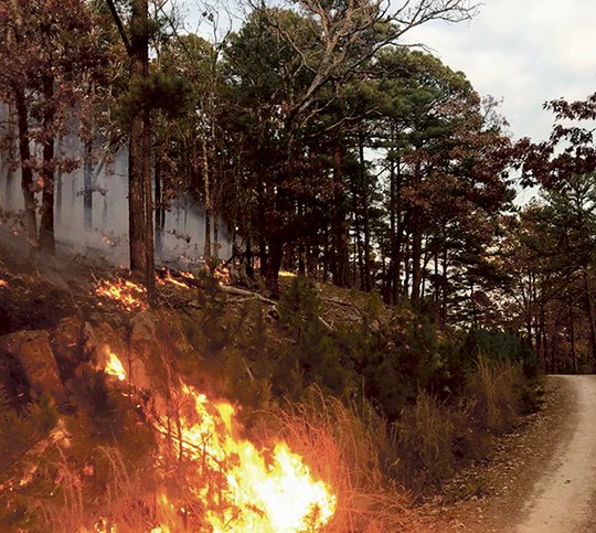
The burn ban Garland County issued Monday followed a busy holiday weekend for the Arkansas Forestry Commission, which reported suppressing 103 wildfires from Thursday to Sunday that burned 1,805 acres across the state.
The burn ban County Judge Rick Davis issued Monday was preceded by the prohibition on outdoor burning Hot Springs imposed Nov. 20 for the corporate limits. The city's ban remains in effect.
Hot Springs Memorial Field has reported three days of measurable rain totaling less than six-tenths of an inch since the county lifted an earlier burn ban Oct. 23. The 0.32-inch total the airport reported Nov. 15 was the last day of measurable rain, accounting for more than half of November's 0.57-inch total. The airport reported a 0.21-inch accumulation Nov. 1 and 0.01 and 0.03-inch totals Nov. 6 and 8.
Trace amounts of less than five-thousandths of an inch were reported Oct. 27 and 31 and Nov. 3, 5, 7 and 17.
November rainfall at the airport is 4.13 inches less than the average for the month. The 1.36 inches in October lagged 4.25 inches behind the average, and September's 0.14-inch total was 3.65 inches less than normal.
The dry fall followed a wet August, with the 3.36 inches reported at the airport outpacing the monthly average by almost three-tenths of an inch.
The AFC reported Monday that 196 wildfires have burned 3,106 acres across the state this month. The total only accounts for wildfires on private property and doesn't include those on state and federal lands.
Garland is one of 29 counties under a burn ban, the AFC said Monday, adding that 59 of the state's 75 counties are at high risk for wildfire danger.
A 741 drought index was reported Monday for AFC's six-county District 5 region, which includes Garland County. The zero-to-800 scale measures moisture levels in the top 8 inches of the soil, with zero representing full saturation and 800 extreme drought.
A 722 index was reported when the county issued an earlier bun ban Oct. 10, dropping to 712 when the ban was lifted Oct. 23.
Local on 11/28/2017