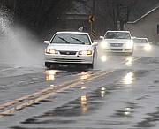
Heavy rains overnight led to flooded roadways, school closures and the third person this week to become trapped by a rain-swollen creek on Friday.
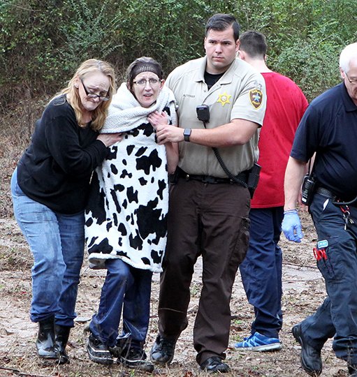
Garland County Sheriff's Department personnel used ropes and a flotation device to rescue an unidentified woman Friday afternoon from the center of the Middle Branch of Gulpha Creek in the 1300 block of Millcreek Road.
Carol Morris, who lives near the creek, said she heard the woman screaming and had her daughter call 911 around 1 p.m.
Garland County Deputy Elwood McConnell, along with Garland County Search and Rescue member Mason McKinney, pulled her to safety using ropes and a flotation device. McConnell said she told him she was attempting to cross the creek using a low-water bridge that was underwater.
Garland County Sheriff Mike McCormick said McConnell had responded to a 911 call on Pate Lane regarding a woman trapped in swift water that was hanging onto a bridge. "The information came in that her foot was also trapped under a large rock as the water was rapidly surrounding her," he said.
McConnell and others, including McKinney, were able to tie a flotation device to a rope and throw it to her. McConnell and the other rescuers were then able to free her foot from the rock and safely pull her to shore where paramedics were waiting to provide medical care, McCormick said.
"If not for the quick actions by Deputy McConnell and the other rescuers, the outcome could have been more severe," McCormick said.
Continued heavy rainfall overnight prompted Entergy Arkansas Inc.'s Hydro Operations office to activate another high-flow event just after 4 a.m. Friday.
"All of our tributaries are continuing to bring significant runoff into lakes Hamilton and Catherine and we will continue to adjust flows from our gates accordingly" at Carpenter and Remmel dams, the Hydro Operations office said in an email Friday morning.
Entergy was releasing more than 40,600 cubic feet per second of water from Remmel Dam into the Ouachita River Friday morning; by midafternoon, the release was nearly 50,000 cfs.
Entergy deactivated the high-flow event at 4:30 p.m. Friday. The peak discharge out of Remmel Dam was "right at" 46,640 cfs, it said in an email.
"Lake levels remain within their winter drawdown level ranges, and the release from Remmel Dam has gone below 30,000 cfs and is continuing to drop," Entergy said.
Garland County faces the probability of more rain and possibly severe weather today and tonight, before the chance of showers finally diminishes, according to the National Weather Service.
The county remains under a flood watch through this evening, with an additional 1 to 3 inches of rain, with locally over 4 inches across the north and west, in the forecast.
The Weather Service said that, given the recent heavy rainfall, the ground has become saturated in much of the region. The runoff potential has increased, making flash flooding and river flooding more likely.
In addition to the flood watch, Garland County also faces the possibility of severe weather today.
"Another round of showers and thunderstorms is expected on Saturday into Saturday night, with more heavy rainfall possible keeping the flooding threat high. In addition to the flooding concerns, there is a chance for some strong to severe thunderstorms Saturday afternoon and evening across all but the northwest portion of the area. The primary concerns will be damaging winds and isolated tornadoes," the Weather Service said in a hazardous weather outlook that included Garland County.
Official rainfall amounts recorded at Hot Springs Memorial Field include 1.31 inches of rain on Thursday, 4.26 inches of rain on Wednesday, and 1.15 inches of rain on Tuesday, according to preliminary climate data posted online by the Weather Service.
David Batson, Entergy's lakes manager, said Wednesday that rainfall amounts varied by location, with western areas of the county, where it began to rain earlier, receiving higher amounts.
According to information posted Friday afternoon by the U.S. Army Corps of Engineers' Vicksburg District Water Control Center, Lake Ouachita had received 3.44 inches of rain in the preceding 24 hours, and has received a total of 10.51 inches of rainfall in the preceding three days.
Lake Ouachita, which was nearly 10 feet below the flood stage level of 578 feet above mean sea level in mid-February, had risen to just around 1.5 feet below flood stage on Friday. The lake, at noon Friday, was at 576.41 feet msl, having risen 2.71 feet in 24 hours.
The county road department closed the section of Speers Circle that crosses Big Blakely Creek after it overflowed the roadway on Friday. Residents who live north of the creek had to take the long way around to get back to Highway 298 in the Jessieville area.
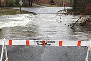
Bo Robertson, director of the Garland County Department of Emergency Management, provided the following list of roads that were impacted by high water on Friday:
• Deerpark Road, Brady Mountain Cutoff bridge, Owensville Road, and the 5500 block of Millcreek Road were impassable.
• The 5500 block of Park Avenue had standing water.
• Water was over the roadway in the 1000, 2500 and 3500 blocks of Amity Road, West Glazypeau, the 3700 block of Park Avenue, and Glazy Acres, but all were still passable.
Editor Mark Gregory, photographer Richard Rasmussen, Managing Editor Steven Mross and staff writer David Showers contributed to this report.
Local on 02/24/2018