Outdoor writer and photographer Corbet Deary is featured regularly in The Sentinel-Record. Today, Deary writes about the Ouachita National Recreation Trail from Forest Road 78 to Highway 298.
I have recently covered four different sections of the Ouachita National Recreation Trail system, consisting of right at 18 miles of designated path. Three of the aforementioned sections connected, and together provided folks with a description of 15 miles of walking opportunity beginning at Highway 27 to its second crossing on Forest Road 78.
In turn, one has the option of stopping at any of the three access points along the way, lending to an opportunity to choose the distance that most fits their time schedule and physical abilities.
That being said, I decided to give readers one more option prior to moving on to other destinations. The section of the Ouachita Trail beginning at Forest Road 78 and ending at Highway 298 will lend to even more choices.
But I also felt compelled to cover this section of beaten path for another reason. Let's face it. Few hiking enthusiasts contrive to tackle the entire Ouachita Trail during one excursion. I, too, share these sentiments. However, I have certainly experienced a sense of completion upon finishing sections beginning at one paved highway and ending at another. And I thought you might also find setting goals of trekking from pavement to pavement both motivating and rewarding.
The trailhead where we'll end this particular hike is easily located. From Hot Springs, take Park Avenue to the junction of highways 5 and 7, just past Fountain Lake School, and take a left. Continue on Highway 7 for 10 miles and turn left onto Highway 298. Follow 298 for about 16.7 miles and the parking area will be on the right just before the highway spans the north fork of the Ouachita River.
To reach the starting point, continue west on Highway 298 for about 1.3 miles and take a right onto Tabor Mountain Road, the second paved road past Mount Tabor Baptist Church. Follow Tabor Mountain Road about one mile and veer left onto Forest Road 78, which will be the first dirt road to the left.
Follow the forest road for about six-tenths of a mile and there is ample room to park on the left just beyond the trail crossing. From the vehicle, head back down to the road and head west (right) along the designated path. Although it might seem as if you are walking in the wrong direction, do not grow concerned. The trail will parallel the road for about eight-tenths of a mile prior to crossing Tabor Mountain Road and heading east, in the direction of the 298 trailhead.
The first segment of the walk is very pleasant, as it makes its way through a predominantly open forest. There is one climb worthy of mention along the way. However, the ascent is gradual and fairly short compared to other climbs we've tackled throughout the past few articles. Even those with joint issues and those who are remotely in decent physical condition should have little issues reaching the climb's end.
We happened upon several spots throughout this 0.8-mile section of the hike where wildlife had been browsing the forest floor for the last of the acorns that had plummeted from the hardwood canopy during the fall. Although I failed to notice any indications that a buck had been using the area during the recent rut, one would suspect that they, too, have been frequenting the area, as food is scarce during this time of the year.
The path eventually tied in with and followed an old road bed into a flat just before crossing Tabor Mountain Road. After crossing the paved road, the path makes its way over an interesting bridge spanning an old, rusty barbed-wire fence. The structure is constructed of crossties and serves well as a means of avoiding damage to the fence.
The path meanders alongside a steep hill for a ways prior to crossing a drainage area and eventually tying into and following a dim road. The trail remains on the road for a distance as it makes its way into another drainage area and runs alongside a small stream. Although water was running in the stream during our recent hike, I cannot say with confidence that it is a reliable water source, as I suspect it dries up during the warmer and drier times of the year.
Although the old roadbed has obviously has not been used for years and is no longer navigable via vehicle, one has to wonder where it once led. Perhaps it was well-traveled prior to the construction of Tabor Mountain Road. Or perhaps it was simply a driveway leading to an old home place that has since been taken over by the forest. Regardless of its initial use, the roadbed is still serving as an important route for hikers today.
The designated path eventually begins another ascent, of which is also mild in comparison to some of the ascents mentioned during previous articles. The climb eventually tops out on a small knoll.
This is one of those spots lurking in the forest that beckons one to stop and spend a little extra time. I'll be the first to agree that distant views of deep valleys and jagged hillsides have been few and far between during this particular hike. But one can actually see a distant Blue Mountain lurking to the north from atop this knob.
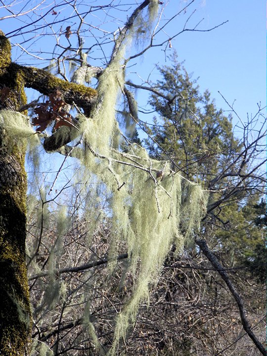
And if the distant view of the mountain is not enough to sway the hiker to stop and savor the scenery, one might consider focusing on the environment around them. Colonies of Spanish moss dangle from the limbs of many trees, and the overturned leaves along the forest floor were a sure indication that a flock of turkeys had recently been browsing for acorns and other food sources.
The trail quickly bid farewell to the knoll as it began a winding journey down the hill, eventually meandering within sight of the North Fork of the Ouachita River. The route was obviously nearing Highway 298, as we also began to hear the occasional roar of vehicles zooming along the road.
The path continued into a low-lying area and made its way to the road's edge shortly thereafter. The journey had not ended, however, as this was one of the few spots, maybe the only spot, where the trail actually utilizes a major highway for a short distance prior to heading back into the woods.
In fact, upon reaching 298, we turned to the left and followed the pavement for probably two-tenths of a mile prior to reaching the parking area and the spot where the trail heads back into the woods and embarks upon a climb that will eventually top out at Ouachita Pinnacle.
Although one might not anticipate the section of trail running along the highway, this is actually the most scenic portion of the hike, as the route actually crosses the bridge spanning the North Fork of the Ouachita River, from where one can enjoy beautiful scenes both up and down the waterway.
From the bridge, the trail continued along the highway for a short distance prior to reaching the aforementioned parking area where we opted to end our hike. Upon completion of the walk, I was aware that I had experienced more impressive scenery during previous excursions. But I was also satisfied with the journey we had just embarked upon, as the pleasant walk had lent to an opportunity to grow more acquainted with a small section of a special and lengthy path referred to as the Ouachita National Recreation Trail.
Local on 01/21/2018