6 p.m. update:
Additional storm damage on Saturday and a substation outage near Hot Springs Village will delay the restoration of power in Garland County until noon Sunday, Entergy Arkansas Inc. says.
An outage at the Mountain Valley Substation near Hot Springs Village on Saturday impacted about 1,400 customers.
Entergy said it is making repairs to the damaged substation equipment at Mountain Valley and would start re-energizing the circuits in that area around 6 p.m. Saturday.
Restoration work will continue throughout the evening, Entergy said, but based on the additional outages and current restoration progress, most of the customers in Hot Springs and Garland County can expect to have power restored by noon Sunday.
Saturday morning's original update:
Entergy Arkansas Inc. estimates it will have most power restored in Garland County by 5 p.m. Saturday, but said it could be late Saturday night until isolated areas are restored.
Jim Garland, Entergy's regional customer service manager, said Saturday morning that the severe thunderstorms that moved through the Hot Springs and Garland County area Friday afternoon left around 7,000 customers without service at the storm's peak.
Lightning and strong winds associated with the storms broke six poles and downed several segments of power lines, Garland said.
Most of the largest outages were in the western part of Hot Springs and along Highway 270 west toward Royal, Garland said.
By 11 p.m. Friday, local lineman had restored power to almost 3,500 customers.
By 7 a.m. Saturday, the number of outages had been reduced to about 2,400.
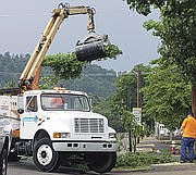
"An additional 100 outside line workers will be working in Hot Springs and western Garland County today. We estimate having power restored to most all customers by 5 p.m. Saturday," Garland said.
"However, some of the more heavily damaged and isolated areas may not be restored until late Saturday night. Entergy appreciates our customer's safety and patience during the repair work."
Original article:
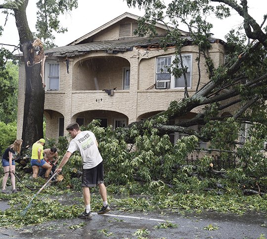
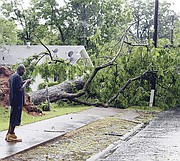
More than 5,600 Entergy Arkansas Inc. customers were without power Friday afternoon after severe thunderstorms swept through Garland County, blowing down trees onto homes, roadways and power lines.
By 4:27 p.m., the National Weather Service said Doppler radar indicated as much as 3 inches of rain had fallen over the area over the past hour or so. A flash flood warning was in effect for early Friday evening.
Two separate severe storms hit the county, a little more than an hour apart. Initially, parts of Albert Pike, Seventh, Rector and Hobson were affected by the outages. Tree damage was also reported on Emory Street and blocking the 900 block of Prospect Avenue.
Traffic signals were also out at several major intersections in the city of Hot Springs, according to the Hot Springs Police Department.
Hot Springs police Officer 1st Class Joey Williams said some of the hardest-hit areas for tree damage included Third through Seventh streets, Rector Street, Greenwood, Hobson and Prospect avenues.
Williams said there were no injuries reported.
He also said there may have been some brief flooding, but no reports of major impacts.
City street crews were already at work clearing the roadways and some streets had to be barricaded to allow the crews to work.
The National Weather Service initially issued a significant weather advisory for southeastern Garland County effective until 3:15 p.m.
At 2:42 p.m., Doppler radar was tracking a strong thunderstorm over Hot Springs, moving northeast at 10 mph, the Weather Service said, with half-inch hail and winds in excess of 40 mph possible.
The National Weather Service later issued a severe thunderstorm warning, including Lake Ouachita, until 4:30 p.m. Friday.
At 3:54 p.m., a severe thunderstorm was located over Lake Ouachita State Park, or 11 miles northwest of Hot Springs, and was nearly stationary, the Weather Service said.
The storm included 60 mph winds and quarter-sized hail.
The Weather Service warned anyone on or near Lake Ouachita to get away from the water and move indoors or inside a vehicle. "Remember, lightning can strike out to 15 miles from the parent thunderstorm. If you can hear thunder, you are close enough to be struck by lightning. Move to safe shelter now! Do not be caught on the water in a thunderstorm," it said.
After the second storm moved through, the power outages extended to the western part of the county, particularly in the Royal area toward Crystal Springs, and including a downed tree in the 1400 block of Marion Anderson Road.
The outages in the western parts of the county included Old Bear Road, Owl Creek Road and a large part of the Highway 270 west corridor.
Local on 06/09/2018