Outdoor writer and photographer Corbet Deary is featured regularly in The Sentinel-Record. Today, Deary writes about Arkansas Post National Memorial.
I recently wrote about a location in Arkansas' Delta that was rich in history. That in mind, I thought this would be a good time to move a little to the west and cover yet another destination that played a huge historical role, during the same era, in our state's history.
Located just over 50 miles southeast of Pine Bluff, Arkansas Post National Memorial sports an interesting story, and played a huge role in our state's historically rich culture.
It all began in the late 1600s. French explorer Robert Caveller, sieur de La Salle, granted the land along the Arkansas River to Henri de Tonti. One might suspect that Henri de Tonti had no idea of the impact his choice to build a trading post along the river, at the Quapaw village of Osotouy, would have on Arkansas' history.
According to information posted by the National Park Service, "Poste de Arkansea" was the "first semi-permanent French settlement in the lower Mississippi River Valley." Of course, this fact alone lent to historical significance. But one could hardly imagine how important the settlement would become, as a tactical location for a variance of armies from the United States and countries abroad.
The Quapaw and French eventually gained a relationship of trust. In fact, they became allies, as the Quapaws protected the French from other Indian tribes.
By the time 1699 rolled around, the post was abandoned, as a result of an overabundance of beaver pelts combined with a stiff British competition. The post was re-established, however, just a few years later under the protection of nearby French troops.
A small portion of the settlers in the vicinity resorted to farming. However, many chose hunting and trapping practices.
Situated on the banks of the Arkansas River, the post was prone to flooding. In fact, as a result of high waters and the aggression of the Chickasaw, the post was forced to pull up roots and head upriver during the mid-1700s.
The new location was somewhat short-lived, however, as the post moved downriver, about 9 miles from where the Arkansas River converges with the Mississippi. The move was strategic, as it was essential to protect the French river convoys during the war with England.
The French ceded west Louisiana, a large part of the central United States at present, to Spain following the French and Indian War during the mid-1700s. Spain then pursued fur trade and also formed an alliance with the Quapaws.
But high water once again reared its ugly head, causing Spain to relocate the post near the original site of the French settlement. And the post was given a new name, Fort Carlos III.
The post weathered attacks from Chickasaws and British Partisans in 1783, but more change neared. France regained Louisiana in 1800 and sold the territory to the United States in 1803.
One might think that the post was in for easy times following the U.S. purchase of the territory. But not so. The U.S. government's decision to open a post at this location in 1805 was a failure as a result of a strong competition with private traders.
Its population was in the neighborhood of 500 in 1810. And many of these residents saw the value in and resorted to farming practices by 1817.
The Arkansas territory came to fruition in the early 1800s, and the Arkansas Post was chosen as its capital. But, as we know, with time comes change. Its economy was "dampened" when Little Rock eventually became the state's new capital, and the population fell to 114 by 1830. The Confederates actually built and used a fort at the post during the civil war. It was, however, destroyed by Union gunboats in 1863.
The town never really recovered, as the railroads increased and river traffic slowed. And to top it all off, the river channel actually changed course in 1912, leaving the post a half mile from the river.
Recognizing its historical significance, Congress designated the Arkansas Post as a national memorial in 1960. Managed by the National Park Service, the destination will hopefully be preserved throughout the remainder of our country's history. But it also plays yet another role of significance, as folks are welcomed to visit the facility and get better acquainted with all that transpired in the vicinity of the post throughout an unsettled time.
Having been several years since I had visited the memorial, I eagerly added Arkansas Post to my itinerary during a recent excursion to the southern section of the state. I recalled a well-kept, park-like setting where one could spend several hours kicking around. If memory served me, one could spend the good part of a day learning interesting historical facts and enjoying a beautiful natural setting.
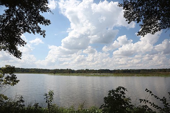
Well, my memory served me well, as I was automatically impressed upon entering the facility. The road leading to the parking area ran alongside the old river channel. Large colonies of lily pads suspended atop the water's surface looked like the perfect spots for largemouths to lurk in the shade and several wading birds fished alongside the shoreline.
I could have spent an entire day simply casting into its waters and photographing nature at its best. But I failed to carry along a fishing rod, and there was much more to see. So I continued onward, to the parking area with anticipations of getting out and enjoying the many other perks awaiting at the facility.
I was greeted by a fella who was both friendly and full of interesting information upon entering the visitor center. After chewing the fat with the fella behind the counter for a while, I got even better acquainted with the area's rich history via several kiosks located in the building.
But I eventually headed outside, as I was eager to see the area first, especially since he shared how the grounds were bountiful with wildlife. I was apt to see a whitetail or two. And with a little luck, I might happen upon a gator basking in the sun.
I struck out along a trail leading alongside a pond and through a large well-manicured field. I stopped and read a couple of monuments along the way, but was most impressed with a huge Bois d' Arc tree. It was massive in comparison to other trees of this particular species that I had seen throughout the state. And I couldn't help but be awe-inspired by its massive stature.
The trail ran alongside several other large trees prior to entering a wooded area. Of course, I have no idea how old these trees were. But I imagined these beautiful specimens being around for many, many years and I pondered how although silent, they had experienced their fair share of history firsthand.
The trail remained level upon entering the woods and eventually ran alongside a huge bayou. Lily pad leaves blanketed the water's surface. This looked like a prime location where I might see an alligator suspending just at the water's surface. But any gators within sight managed to go undetected.
I did happen upon a lone whitetail, however. The large doe was obviously aware of my presence. But she felt safe in the midst of the understory and had no intentions of giving away her whereabouts. She remained totally motionless for several minutes. She never as much as twitched an ear until comfortable any potential danger was out of sight.
The trail eventually crossed a small bridge spanning a stream. This, again, looked like a perfect spot to see a gator, as the water slowly moved through aquatic vegetation. But I once again failed to see any of these beautiful and primitive looking reptiles.
The trail eventually left the bayou behind and continued through a wooded area. And before long, I noticed a flash of a small mammal bounding through tall grass and to the side of a large oak. Easing closer I noticed a large raccoon easing up the trunk to a wad of vines. Although raccoons are plentiful throughout the state, I found the opportunity to see one going about the everyday rituals during daylight hours somewhat exciting.
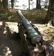
The trail eventually ran alongside a cannon and several shallow sump-holes in the substrate. The cannon was obviously not one which had been used during confrontations at this location. However, the sump-holes were of great interest, as they were actually foxholes, of a sort, that were dug and used during previous wars.
Although the atmosphere, was serene during my recent visit, I imagined a time when men actually took cover in these shallow pits. I painted a scenario in my mind when the air was filled with fear and uncertainties, and the moment grew somber when I came to the realization that some men might have actually died while holing up there.
The trail eventually looped back into itself and ran alongside the remainder of the aforementioned pond, prior to paralleling the old river channel and leading to a replica of the fort that was destroyed by Union fire during the Civil War.
Following the path back to the vehicle, I prepared for a ride back home. And although I would be leaving this spot that was rich in history, I would be carrying the interesting facts that I had learned. And I would surely return to the Arkansas Post National Memorial in the future with an eagerness to get even better acquainted with this particular section of the state and her rich history.
To get to Arkansas Post National Memorial from Hot Springs, take Highway 270 east to Malvern. Turn left onto West Page. Go 2.7 miles and keep right on Highway 270. Drive 40 miles and merge right onto Highway 65 south toward Pine Bluff. Go 13 miles and continue on Highway 65 south. Travel 29 miles and take a left onto East Jackson Street. Go 8.4 miles and turn right onto Highway 212 west. Go 3.4 miles and take a left onto Highway 165 south. Travel 4.4 miles and turn right onto County Road 169. Go 2 miles and take a right onto Old Post Road. Travel eight-tenths of a mile and the destination will be on the right.
Local on 10/23/2018